Flat Jane Austen in Providence
History of the Waterfront
Edior's note: Jane wishes to describe how much Providence has grown over the last nearly 200 years since Roger's day. We walked under the former Great Salt Cove to explore the growth of the town.May 20, 1816
My dearest friends,
You must allow me to educate you further on the geography of this town. It is quite unique to anything I have seen before.
The Moshassuck and Woonasquatucket rivers flowed into the Great Salt River (Providence River) and Providence has grown on top of the three rivers. The Woonasquatucket River flowed slowly through a broad valley of salt marshes.
Do you spy a familiar name of this map?
That is not Benedict Arnold of the War for American Independence but rather his great-grandfather, a president and governor of the Colony of Rhode Island and Providence Plantations.
By 1700 the town had grown quite a bit. The cove covered several hundred acres and was deep enough to accommodate sailing ships. A drawbridge connected the East Side to Weybosset Point.


The First Baptist Church in America was built in 1775, long after Roger Williams founded and then left the church. The market building and college edifice were built in 1770. I shall journey forth to see them all later.
Now here is a map from only a decade or so ago in '03.


In July of last year (1815), the town's harbor lines were extended to the lower harbor. The head of navigation became Weybosset, south of the cove. Providence is growing rapidly and there is much talk about a steamboat ferry between Providence and Newport (1817). They say steam engines are the way of the future and are more in use here than they are back home as yet.
Editor's note:
 |
| Providence in Roger's day Three rivers converge at the Great Salt Cove. They could be traversed at low tide. Susanna's mother, grew up on the other side of the Wampanoag Trail in what was known as Seekonk and then Rehoboth (1644) in Plymouth Colony. There is a cove there too, Watchemoket. |
 |
That is not Benedict Arnold of the War for American Independence but rather his great-grandfather, a president and governor of the Colony of Rhode Island and Providence Plantations.
 |
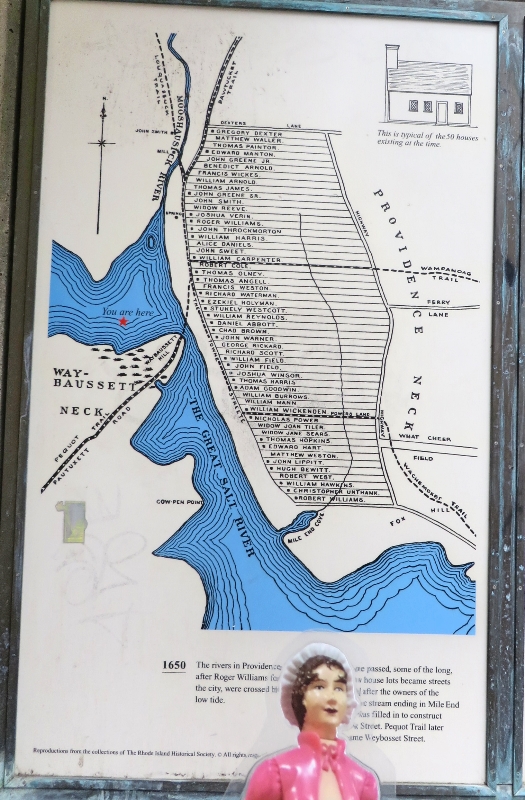
| A better look at the house lots in Providence. Chad Brown was a minister and the great-grandfather of John Brown! |
The first bridge across the Providence River was built in 1660. The first wharf behind Towne Street (South Main Street) had been built and the center of town was now called Mohassack Square. Market Square is located at the south edge of the cove and became the center of Providence (see next page). The town's growth was spurred by shipping and seafaring interests, textile manufacturing, bleacheries, printworks, foundries, ironworks, and machine firms. (Many owned by John Brown and his family).
The First Baptist Church in America was built in 1775, long after Roger Williams founded and then left the church. The market building and college edifice were built in 1770. I shall journey forth to see them all later.
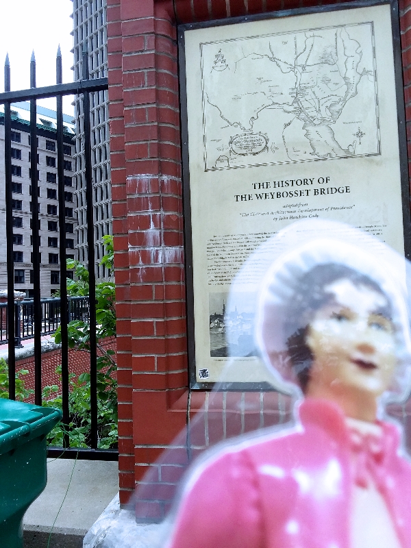 |
| Jane at the Weybosset Bridge Read the text of the sign |
In colonial times, a bridge was built on the western side of town, called Weybosset. It provided a link between what is now Providence to the path to the Pequot lands in Connecticut. After only about a decade, in the 1670s, the bridge fell into disrepair. People and animals were forced to ford the crossing until 1711 when a new bridge was constructed. That bridge was destroyed by flood a few years later. The fourth was blown away by gale force winds in 1761.
 |
| Jane at the site of the Weybosset Street Bridge The newest, late 20th century bridge (1994) links the east side with downcity. |
In 1764 a drawbridge was built to accommodate the square-rigged ships carrying cargo from the West Indies. Providence was by then a major shipping port and more wharfs had been built behind Towne Street. THAT bridge disappeared in last year's gale (1815) and has been replaced by a fixed bridge, preventing sea-faring vessels from entering the cove.
 |
| Providence 1790 by John Fitch |
The city was blocked by several hills and more land was needed. The Great Salt Cove was filled in beginning as early as 1780 in order for more wharves to be built. By 1792 the east side of the cove was filled in creating a new street called North Water (Canal) street.
Now here is a map from only a decade or so ago in '03.
Both sides of the river have been developed since 1784 and new wharves built. John Brown built a new harbor on Narragansett Bay to accommodate his ships making the route to Africa for slaves and the West Indies for sugar cane and back home to collect rum for the return voyage. This place is called India Point after the shipping route. The Indians called this part of town Moshassuck. Shipping and commerce forced the center of town to move south and across the river. The merchant fleet consisted of 120 ships.
 |
| Looking towards John Brown's house with his ships docked in harbor behind me |
.
A great gale blew through Providence September last and destroyed much of the city, including the drawbridge and sent ships flying into the structures along the waterfront. A new, fixed bridge, was built at Market Square. The cove has become a tidal lake.
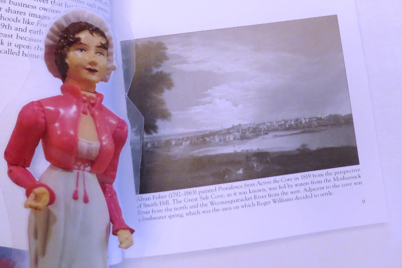
Here is a view of what Providence looks like now.
To the east of the Great Salt Cove where the city edges into the bay is Tockwotton (Foxes) Hill. When Mr. Williams first came it was wooded with many foxes running around. The Narraganset called the place Tockwotton, a word which hear means either "that which is frozen" or "steep ascent to be climbed."
 |
| Behind Jane is Tockwotton Hill now known as Fox Point |
In July of last year (1815), the town's harbor lines were extended to the lower harbor. The head of navigation became Weybosset, south of the cove. Providence is growing rapidly and there is much talk about a steamboat ferry between Providence and Newport (1817). They say steam engines are the way of the future and are more in use here than they are back home as yet.
I have much to do tonight but will write again tomorrow.
Most sincerely yours,
Jane
Take a closer look at the maps and bridges . Jane would like to thank the Rhode Island Historical Society for their signs; 41° North February 6, 2018/Winter 2018 issue for filling in more details; The College Hill Independent Dec. 5, 2014 issue for the history of Tockwotton. Read more about Fox Point before moving on.
Jane owes a debt of gratitude towards the editor's mother for the pictures of India Point and Tockwotton Hill (Fox Point). She's standing in East Providence looking west across the Seekonk river to Providence in the other direction from the period painting.
No comments:
Post a Comment